Sunday morning Sep 30
Got into Bozeman, Montana Friday evening.
Forcast then was for snow in the mountains west of here,
snow warnings active till 6PM Saturday,
so we holed up here for another day.
Almost caught up on posting pictures.
Look for pictures and notes from three days in Yellowstone
to be posted soon.
Planning to make miles today on I90 West.
Not going to Glacier NP because the
"Going To The Sky" main park road is closed;
might visit either Mt. Rainier or Mt. Saint Helens
before going to Seattle.
===
Sunday, September 30, 2007
Grand Teton NP 9/25


Saturday, September 29, 2007
XC_text_4_Teton.doc
XC_text_4_Teton.doc
Tue 25-Sep-07 West Yellowstone. MT
Sunday was a gloomy forecast and we wanted to stop in Salt Lake City
which was only a couple hundred miles, so we slept a bit late and proceeded
leisurely. Turned out to be a pretty nice day, another nice drive on US89
most of the way, only got on I15 when approaching SLC.
We met up with family friend and Brettl-Hupfer Ben Rainville,
had dinner with him,his mom, and girlfriend Christy
who’s a specialist in mountain meteorology (i.e. weather).
Then it was dark and really raining so we only went a little further,
and checked into the first motel we found in Ogden, UT
Forecast for Monday Sept 24 was for lots of rain,
but actually we only encountered intermittent rain.
When we looked out at the mountains
behind our motel we saw snow on the mountain tops.
Took US89 all the way up (avoiding the I15).
This was another really beautiful ride!
Actually drove through a light snowfall in one of the passes.
The road goes through Snake River Canyon
with lots of turnoffs, picnic stops, rest areas, etc.
Passed through Jackson, WY(near Jackson Hole ski resort)
expecting to find a motel in thenext town or two,
but that put us inside Grand Teton National Park
so we stayed at a park lodge facility which was a really neat log cabin deal.
Tuesday (today) we took a naturalist-guided hike up to Inspiration Point,
which started with a shuttle boat ride across Jenny Lake;
real hat-and-gloves weather, no more top down cruising weather.
Continued on into Cascade Canyon a little.
(Dan would not take a picture of the snow along the canyon trail
so we have no proof of hiking in the snow.)
Partially storm cloudy with sunny breakthroughs,
making for really spectacular scenes.
Lots of snow up in the mountains.
They have about half a dozen active glaciers within Grand Teton National Park.
After Teton, we continued up US89 which segues directly into the south
entrance to Yellowstone National Park. In-park lodging was outside our
budget so we drove through (85 miles) and out the West entrance into the town of
West Yellowstone, Montana, where we found a nice family-run motel
and signed in for three nights. Weather is now pretty nice,
should be OK tomorrow and warm and sunny all day Thursday
so we should have a real nice two days in Yellowstone.
Snake River 9/24
Monday Sept 24
Drive from Ogden, Utah to Grand Teton National Park, Wyoming
on US89 through Snake River Canyon
Early morning, starting out from Ogden. First snow we saw.

A deceptively tranquil scene.
We drove through a light snowfall in a high pass.

Views in the Snake River Canyon at a spot labeled
Big Kahuna / Lunch Counter
Looking downstream

Looking upstream

Just looking

A few sky pictures I liked


Here's our stay for the night at Colter Bay, Grand Teton National Park


Bryce: On The Road Again 9/22
Left Bryce National Park lunchtime Saturday Sept 22.
Driving east / north on Utah Route 12
through Grand Staircase - Escalante National Monument
It rained for most of this stretch,
scenery was still grand.
Rain has been rare during this whole trip.
Got these piuctures during a break in the rain.


Driving east / north on Utah Route 12
through Grand Staircase - Escalante National Monument
It rained for most of this stretch,
scenery was still grand.
Rain has been rare during this whole trip.
Got these piuctures during a break in the rain.


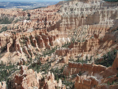
Bryce: Day 2 9/22
Bryce Canyon National Park
Saturday Sept 22
Drove the 18-mile Park Road all the way south and back,
with frequent stops.
Here's a few views.


Saturday Sept 22
Drove the 18-mile Park Road all the way south and back,
with frequent stops.
Here's a few views.


Bryce: Descent Into Canyon 9/21
Bryce: Descent Into Canyon
Late Afternoon Friday Sept 21
Still had a few hours of light,
and it looked like the threatened thunderstorms would hold off,
so we embarked on a hike down into the vertical scenery. AND WE MEAN VERTICAL!
This was the most awesome trail we have EVER been on.
Dan was somewhat spooked and hesitant to proceed,
but Rosemary forged ahead and down we went…
550 feet down in about 0.6 miles.
We then walked out via Queens Garden trail,
regaining the 550 feet in 1.8 miles
Navajo Loop Trail, Wall Street Branch
This trail had been closed for a long time due to a rock slide,
and just re-opened during the day today;
they didn't have the signs up yet.
From the National Park Service website:
"
Navajo Loop Trail
It is with great pleasure
that we announce the reopening of the Navajo Loop Trail.
The trail has been closed since May of 2006 when 400-500 tons of rock fell
and blocked the Wall Street section of the trail.
The park decided to construct a trail over the rock fall
with steps leading out of Wall Street on the steeper lower side.
"
Look at
http://www.nps.gov/brca/parknews/navajo-loop-trail-rock-fall.htm
Looking down into a slot full of switchbacks.
Little dark dots down there are humans.

Another human on the trail.

Looking back up from about half way down.

A scene near the bottom.

Walking back out on Queens Garden trail.

Bryce: Rim Trail 9/21
Bryce Canyon National Park
Rim Trail, Bryce Point to Inspiration Point
Friday Sept 21 afternoon
Views in three directions (approx N, W, S) from Bryce Point


An interesting formation


This view is from Inspiration Point

Rim Trail, Bryce Point to Inspiration Point
Friday Sept 21 afternoon
Views in three directions (approx N, W, S) from Bryce Point


An interesting formation


This view is from Inspiration Point


Zion: Rte 9 views 9/20
Zion: Thursdayy Sept 20
We took 91 pictures in Zion NAtional Park.
Here's a small sample.
These are snapshots documenting that we were there;
they are NOT photographs of the scenery.
This scenery does not fit into the camera,
especially a small pocket-size point-and-shoot digital.
See that hole in the side of the cliff ?
That's a window into the mile-long tunnel.
When they built the tunnel, they worked not only
from each end, but also from a few waypoints;
they entered, and removed material,
through about three portals such as this.

Just a few typical views ....


Zion: MtCarmelJct 9/19
These four pictures show just about all of Mt. Carmel Junction,
a dot on the map just east of Zion National Park.
We stayed two nights here.


These four pictures show just about all of Mt. Carmel Junction,
a dot on the map just east of Zion National Park.
We stayed two nightsa here.
a dot on the map just east of Zion National Park.
We stayed two nights here.


These four pictures show just about all of Mt. Carmel Junction,
a dot on the map just east of Zion National Park.
We stayed two nightsa here.
Subscribe to:
Comments (Atom)